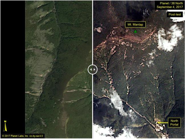
Signs that multiple landslides have occurred around North Korea’s nuclear test sites have been spotted in commercial satellite imagery, a US-based North Korean watchdog reported on Wednesday.
According to satellite images released by Planet, the areas near Punggye-ri nuclear test site displays surface disturbances -- they are centered on and around Mantapsan that embraces the blast zones, the North Korean watchdog 38 North explained. The photo also shows clear differences between pictures taken on Friday, two days before the Pyongyang’s sixth and strongest detonation.
“The land turbulences appear to be more numerous and widespread than the previous five tests that the communist regime had conducted,” the watchdog, which is linked to Johns Hopkins University in the United States added.
 |
Satellite images show the Punggye-ri nuclear test site before and after North Korea‘s sixth nuclear test. (38 North-Yonhap) |
It was also noted by 38 North that there has not been any evidence of a collapsed crater as might have been suggested from the post-test tremor.
There have been speculations that the underground tunnels were likely to have collapsed resulting in a quake of 4.1 (US Geological Survey) that followed minutes after the initial shake.
Other damages, such as collapsed buildings could not be found and further analysis may be possible with higher resolution imageries when they become available.
North Korea on Sunday announced it had successfully conducted its sixth and the strongest nuclear test, hours after a large earthquake was detected in the North Hamgyeong Province.
Regarding radioactive materials that may have been released into the atmosphere, South Korea’s Unification Ministry said on Wednesday it is closely monitoring for signs. The nuclear safety agencies here said they have not yet detected any traces of radioactive materials.
“We are closely watching over the situation considering the seriousness of the damage such radiation exposure can incur,” Baik Tae-hyun, the ministry spokesman told reporters.
A day before in a parliamentary briefing, Unification Minister Cho Myoung-gyon also confirmed that North Koreans living near the test site could have been exposed to radiation after the detonation.
Seoul’s Nuclear Safety and Security Commission and Korea Institute of Nuclear Safety revealed that they have not found any traces of radioactive materials, including xenon gas, following the North’s test. They analyzed the data they collected immediately after the nuclear test, Sunday, until noon the next day.
Japan on Tuesday increased its estimated size of the rogue regime’s latest nuclear test to a yield of around 160 kilotons, following a revised magnitude of 6.0 by the Comprehensive Nuclear-Test-Ban Treaty Organization.
“This is far more powerful than their nuclear tests in the past,” Japanese Defense Minister Itsunori Onodera said.
The prospected figure -- upgraded from the previous 70 kilotons and 120 kilotons -- is 10 times stronger than that of the Hiroshima explosion in 1945, which carried a yield of 15 kilotons.
Previously, the CTBTO had raised its estimate of the seismic event from its previous 5.8 to 6.1 in magnitude.
The estimated figures are recorded differently by institutes in related nations. The US Geological Survey announced the earthquake measured 6.3 in magnitude, while the record of Seoul’s Defense Ministry appeared to be the lowest, at 5.7 magnitude. It said they estimate the latest detonation carried a yield of 50 kilotons.
(
herim@heraldcorp.com)


![[Today’s K-pop] Blackpink’s Jennie, Lisa invited to Coachella as solo acts](http://res.heraldm.com/phpwas/restmb_idxmake.php?idx=644&simg=/content/image/2024/11/21/20241121050099_0.jpg)
